


São Jorge
With a length of 54 kilometers and a maximum width of 6.9 kilometers, São Jorge appears as a long volcanic mountain range stretching from northwest to southeast. Its total area is 243.9 km2 and is home to 9,171 inhabitants (2011 data). The island of São Jorge is part of the Central Group and is one of the vertices of the so-called “triangle islands”, together with Faial and Pico, from which it is 18.5 km away. The highest point on the island, at an altitude of 1053 m, is located on Pico da Esperança, at 38°39’02” north latitude and 28°04’27” west longitude.
Given its proximity to Terceira, it is believed that portuguese navigators came across São Jorge together with the other islands that surround it. Everything indicates that the settlement began around 1460, being the second island of the central group to be inhabited. After a decade, several population centers have already been established on the west and south coasts, including Velas. The arrival of the Flemish nobleman Wilhelm Van der Haegen in 1480 marks the foundation of the community of Topo, at the eastern end.
In 1483, the captaincy of the rapidly developing island was donated to João Vaz Corte Real, then captain of Angra, in Terceira. The town charter was granted to Velas at the end of the 15th century, a boon extended to Topo in 1510 and to Calheta in 1534. Prosperity was based on wheat, but from an early age the island also stood out for the quality of its pastures.
Vowed to a certain isolation due to the absence of safe ports, São Jorge does not acquire great economic protagonism. In the 16th and 17th centuries, it received unwanted visits from English and French privateers and ruthless Turkish and Algerian pirates. The incursion of the Frenchman Du-Gray-Trouin in Velas, in 1708, is famous. Defeated by the heroic resistance of the population, this privateer leaves São Jorge with high losses in the crew.
Between the 16th and 19th centuries, the life of the inhabitants was buffeted by agricultural crises, which caused food shortages, and by earthquakes and volcanic eruptions, which caused considerable destruction. The economy follows the agricultural and livestock model of the other islands: wheat and vineyards; heather collection; cattle raising which soon generates important secondary sectors linked to cheese and wool. The fishing activity assumes importance between the end of the 19th century and the 20th century, first through whaling and, since the 1960s, through tuna fishing. Currently, the excellence of São Jorge’s pastures is reflected in the production of a typical cheese made from raw cow’s milk, with Protected Designation of Origin, making this island a Demarcated Region for the production of São Jorge cheese. The existence of an airport and modern ports in Velas and Calheta contribute to the full integration of São Jorge in the archipelago and in the world.
The elongated shape of the island and the rhythmic sequence of cones that characterize its central part appear on the horizon like the undulating back of a sleeping prehistoric animal. The plateau of the most interior part of the island, where the volcanic cones that generated the island are born, gives way to steep and very high slopes that fall into the deep blue ocean or that end in small flat areas at sea level, in the famous fajãs of Saint George.
The green of the forests and semi-natural pastures, the brown of the agricultural lands, the black of the rocky points and the blue of the sea complete a palette of colors and shades. The presence of numerous dragon trees and fragments of endemic vegetation in closed valleys, protected from the onslaught of Man, are a hallmark of the island.
The “fajãs”, a name also used in the Macaronesian archipelagos of Madeira and Cabo Verde, are the main ex-libris of the Jorge landscape. Flattened surfaces formed by the sea and bordered by more or less imposing cliffs, the fajãs result either from lava flows that advanced into the sea (as is the case of Fajã do Ouvidor), or from land and rock loosenings down the slope (as is the case of Fajã dos Vimes) due to earthquakes, heavy rains or other instabilities that affect the cliffs.
The fertile soils, the protection against the strong winds and fog that are felt in the highest central part of the island and the favorable climatic conditions that they present, captivated the inhabitants for the permanent cultivation of these tiny plains, despite the difficulties of access to some of them. From beans to bananas, from yams to coffee, from potatoes to oranges, everything seems to thrive in these areas, where the imposing dragon tree is not shy about growing. Over the years, the growing demands of modernity and its vulnerability to natural whims, several fajãs were abandoned by the residents, but many still remain inhabited all year round, or only at certain times, mainly associated with festivities and agricultural activities.
The more than 70 fajãs on the island of São Jorge symbolize the natural beauty and isolation that has dominated part of the island’s history and offer extraordinary and unique panoramic views that are best explored by taking advantage of the island’s existing network of footpaths. From the detrital Fajã dos Cubres and Caldeira de Santo Cristo with its coastal lagoons, to the lava Fajã das Velas, Almas or Ouvidor, there is a wide range of places to enjoy.
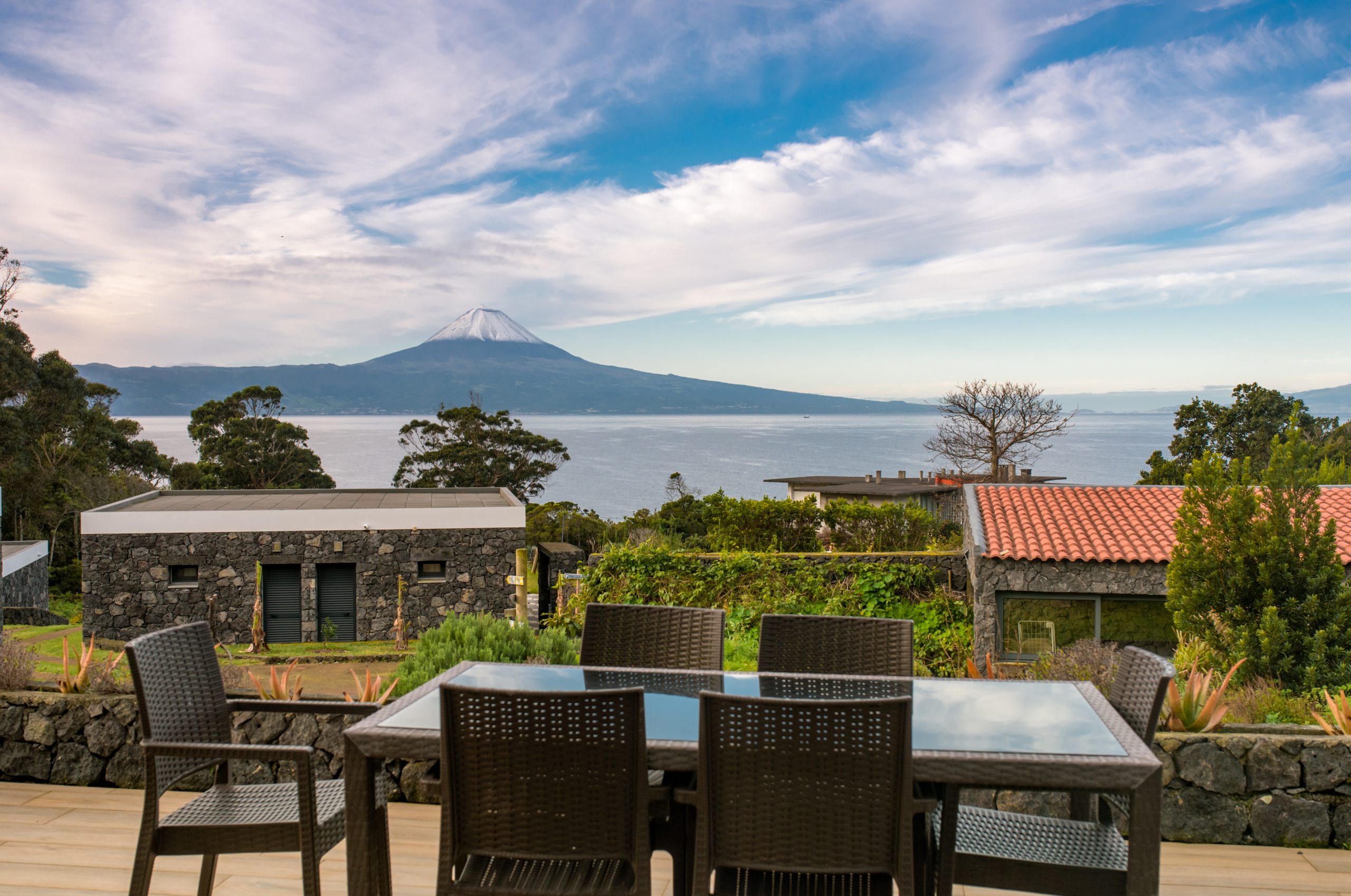
The volcanic nature of the island can be appreciated by walking along the roads and paths that wind through the central mountain range of São Jorge, where two hundred small cones display their once active craters, now gently occupied by small lagoons, temporary ponds or peat bog areas. The Picos da Velha, Esperança or Areeiro have marked viewpoints, which provide stunning views over the coastal area and from where, looking up, you can glimpse the contours of the islands Faial, Pico, Graciosa and Terceira, so distant and at the same time so close.
The crossing of this undulating back is yet another invitation to discover and enjoy the nature of São Jorge, where the craters of Bocas do Fogo, active in 1808, are followed by natural and semi-natural pastures, which wild rabbits and kites use as habitat. A bunch of hydrangeas delimit the pastures and patches of cryptomeria and heather make up the island’s vegetable frame.
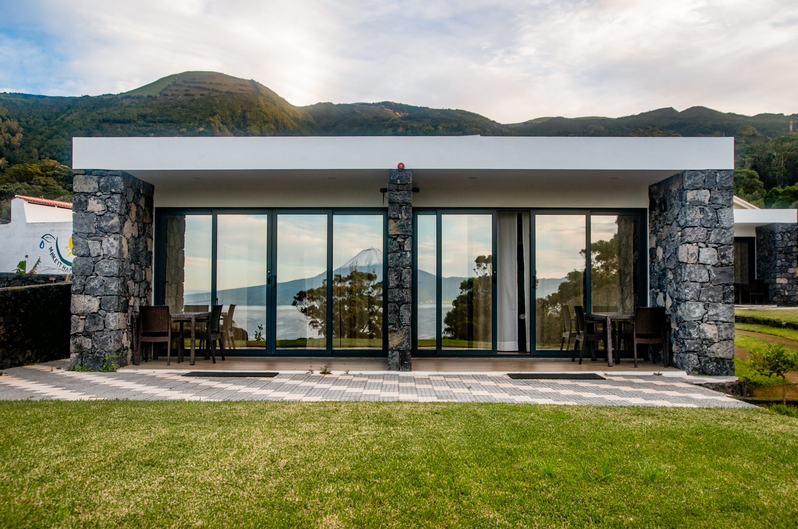
In addition to its fajã characteristics, the coast of the island is characterized by the towering Ponta dos Rosais, facing Faial, and by Ponta and Ilhéu do Topo, on the east side, which enhance the natural beauty of São Jorge and allow superb views over the Ocean.
The coastline of the island includes rocky and sharp points that penetrate the sea, small and sheltered coves, cliffs several hundred meters high that fall almost vertically into the surrounding sea or, even, cones of submarine volcanoes degraded by the erosive action of the sea, as is the case of Morro de Lemos and Morro de Velas.
Despite the relatively small area of the island, the extensive coastline that results from the elongated shape of São Jorge enhances a vast mosaic of places and scenic settings, where the visitor can look for the best angle for a special photograph, taking advantage of the color of the rocks, the shades of endemic or natural vegetation or the grace of a seabird at rest or in flight.